Not only in Böheimkirchen there has been an increase in flood incidents since 1997. The periods between the individual flood events are becoming shorter and shorter. In addition, heavy rainfall intensifies the situation. To enable a faster and more comfortable flow of information in case of emergency, the purchase of four wasserstand.info level stations with the associated software was decided for the municipality of Böheimkirchen and the Perschling Water Federation.

The problem
The pre-warning from the authorities and the weather reports of the central institute for meteorology and geodynamics are summarized for the early warning. At a certain level personal observations are also taken into account. In the municipality of Böheimkirchen and the surrounding area only manual reading points are available. In order to obtain a comprehensive picture of all relevant levels high efforts are necessary. This includes a lot of telephone calls and the reading points must be checked on the spot. Usually when flood incidents are threatening, the weather is cold, wet, the roads are not always easy to pass and it is often dark.
The goal
“It is not always possible to draw conclusions from a flood event to another”, explains Gerhard Lechner, local manager of the municipality of Böheimkirchen. “In 2009, there has been longer rain events spread over a few weeks. There was rainfall again and again. The soils were all saturated and the rivers had a critical high water level. On the morning of the 10th of July we dismantled the flood protection. Due to strong rainfalls in the neighbouring community we started building up the flood protection again within 5/4 hours. We were fortunate that the communication between the mayors of the communities worked excellently. The mayor of Stössing called our mayor and he called me. In this case everything has worked fine. It is nevertheless an objective that we should make these information processes more comfortable in the 21st century. With wasserstand.info the levels can then be checked online and the responsible person can have a look.”

“The disaster alert is issued by the district administrative authority. But the district administrative authority needs a source of information. This determination of the water level has always been done manually. We hope that the pre-warning levels as well as the water levels can be retrieved at any time from any location from the operational forces and the civil protection”, sees Manfred Rumel, chairman of the Perschling Water Federation advantages of the wasserstand.info system.
Not only the municipality of Böheimkirchen will benefit from the level measurement and the access of the information via the wasserstand.info system. The subterranean communities – Kappeln and downstream Perschling – will also be able to react much faster than at the moment, where personal and telephone contact is necessary.
The next steps
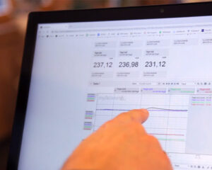
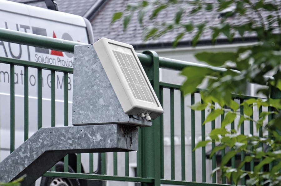
First the level stations are mounted. “The neuralgic points are known on the basis of experience. We have looked where a measurement is meaningful and how the feeder can be measured with favorable positioning”, explains Manfred Rumel the positioning of the level measurement stations. The level measuring stations are delivered ready-made and have to be mounted – for example on a bridge. With the robust solar panel the level station operates completely self-sufficient. The data is transmitted via GSM to the central server and can be retrieved at any time.
“We are now in a step-by-step plan and start mounting the level measurement stations. In the first phase the information is accessible to a selected group from the municipality and the fire department. In the final version, this can of course be a possibility for citizens, too. However, before that the special alarm plan must be made. The alarm sequence and the task of the respective operational forces must be defined. The rulebook can only be a success, if the information is correspondingly effective. There has to be responsibilities for the alerting of the citizens. Each situation has to be assessed individually, based on measurement values and experience,” Gerhard Lechner explains the further steps.
Best Practice
The fire brigade Ruprechtshofen has been using the wasserstand.info system for several years. Citizens can register via the website www.wasserstand.info for the relevant level. In a two-step alarming process the fire brigade can alert affected citizens by SMS. When a defined limit value is exceeded, the level measurement station automatically sends an SMS to the responsible persons of the fire brigade. The emergency personal can now inform (after an additional on-site inspection) all registered citizens by clicking a button.

Mit dem Laden des Videos akzeptieren Sie die Datenschutzerklärung von YouTube.
Mehr erfahren